-
 The National Weather Service is confirming a fourth tornado during last weekend's severe winter weather outbreak.It touched down in southwestern Houston County, along Decatur Road, on Sunday afternoon.The EF0 had winds of up to 85 miles-per-hour.
 -
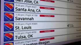 A massive winter storm set the stage for a brutal travel day Sunday, with airlines warning of widespread cancellations and delays at some of the nation's busiest airports. The disappointment of lost flights is being felt in Alabama as well. The website Flightaware says Huntsville International Airport had forty one cancellations as of this morning. Farther south, Birmingham Shuttlesworth International had forty seven.
 -
 Alabama Governor Kay Ivey issued a state of emergency ahead of the icy blast approaching the state. Ivey signed the proclamation for nineteen northern counties
 -
 Millions of Americans from New Mexico to Alabama to the Carolinas are bracing for a potentially catastrophic ice storm that could crush trees and power lines and knock out power for days, while Washington, D.C., Philadelphia, New York City and Boston could see enough snow to make travel very difficult or nearly impossible, forecasters say.
 -
 The National Weather Service in Huntsville says the Tennessee Valley, including the Huntsville area and the Shoals, could be in for a winter emergency starting as soon as Friday night. A cold front from the north combined with moisture coming up from the Gulf of Mexico could lead to roads left impassible by snow and ice.
 -
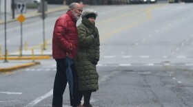
 Huntsville, Dothan, Birmingham, and Garden City in Cullman County spread the word early about the brutal overnight cold. The low temperatures along the Tennessee Valley, over the weekend and into Monday morning, are forecast to be as low as the mid teens. Even the Wiregrass region toward the south was predicted to be in the mid-twenties.
 -
 Space weather forecasters issued an alert for incoming severe solar storms that could produce colorful northern lights and temporarily disrupt communications. This may result in an "Aurora Borealis" or Northern Lights, as far south as Alabama.
 -
 The cities of Montgomery and Birmingham and the Jimmie Hale Mission will have warming stations open night as some of the first blasts of winter weather hit Alabama. Low twenties are in the forecast from the Tennessee Valley to Tuscaloosa and the Magic City. The Gulf coast is expected to be closer to thirty.
 -
 Some of the first wintry weather of the season is on the way for much of the U.S. in the coming days, including potentially record low temperatures for parts of the South and snow in the Northern Plains. Alabama woke up in the upper twenties in Huntsville, upper forties in Mobile, and mid thirties over much of the rest of the state. Chillier conditions are yet to come.
 -
 As forecasters with the National Hurricane Center watch the progress of Hurricane Erin, weather watchers say the most powerful storms tend to form later in the year.

Digital Media Center
Bryant-Denny Stadium, Gate 61
Box 870370
920 Paul Bryant Drive
Tuscaloosa, AL 35487-0370
205-348-6644
© 2026 Alabama Public Radio
Bryant-Denny Stadium, Gate 61
Box 870370
920 Paul Bryant Drive
Tuscaloosa, AL 35487-0370
205-348-6644
© 2026 Alabama Public Radio
Play Live Radio
Next Up:
0:00
0:00
Available On Air Stations


